Smarter Offshore Survey Planning with TrackPlanner

The Problem: Inefficiencies in Line Planning Are Costing You
In offshore surveys, time really is money. Vessel operation costs can easily exceed tens of thousands of euros per day. Yet many offshore survey projects still rely on outdated, manual planning methods—often involving spreadsheets, rudimentary maps, and a fair bit of guesswork. These traditional workflows typically take anywhere from half a day to five full days per project just to create a line plan and get the survey parameters for the bidding or survey execution phase.
Even worse, this manual approach introduces risk:
- It’s difficult to accurately estimate survey time, coverage, and data volume
- Surveyors lack terrain-informed insights, leading to inefficient track orientation and data quality
- The absence of integrated data export formats causes friction between planning and execution
All of this adds up to missed deadlines, blown budgets, and compromised data quality—especially when working with sensor arrays such as multibeam sonar, sub-bottom profilers, or magnetometers in complex bathymetric environments.
The Solution: TrackPlanner by north.io
TrackPlanner is a next generation planning tool purpose built for the offshore industry. Whether you're conducting surveys with autonomous surface/underwater vehicles (ASVs, AUVs), remotely operated vehicles (ROVs), or traditional crewed vessels, TrackPlanner helps you plan smarter, faster, and more accurately.
Key Features:
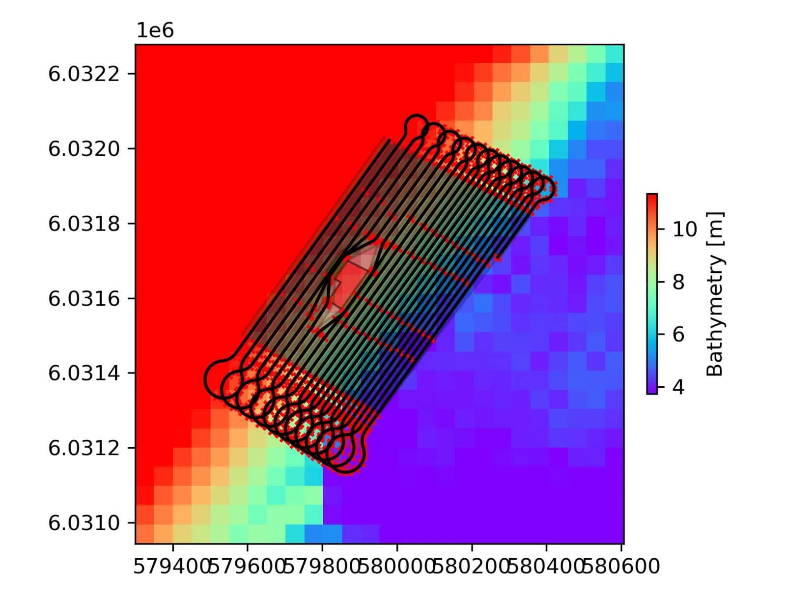
- Bathymetry-Aware Track Generation: Uses terrain data to orient survey lines for optimal coverage, data quality, and efficient survey time.
- Multi-Area Planning: Compute track lines for several survey blocks in one go.
- Sensor & Mission-Aware: Tailored plans for data quality requirements and specific sensor configurations.
- Automated Output Generation: Exports include:
- Navigation files: .rtz, .csv, .nmm
- Planning files: .geojson, .shp, .dxf, .gpkg, .geoparquet
- GIS-ready overview maps and data quality stats
TrackPlanner also estimates total survey distance, time, number of turns, and expected data volumes — enabling you to plan operations down to the minute.
What’s In for You: From Days to Minutes
For surveyors, project managers, and offshore developers, TrackPlanner delivers measurable value:
Efficiency Gains
Cut planning time from days to under 1 hour. Focus more on execution, less on prep.
Improved Bids and Project Control
Submit more accurate bids with confidence. Precise planning boosts your chances of winning contracts—and staying within budget once operations begin.
Reduced Operational Risk
By incorporating terrain and sensor-specific parameters, you reduce overlap, minimize data gaps, and ensure the required data quality.
Repeatability & Standardization
Reuse and adapt plans across projects. TrackPlanner’s structured outputs and templates support better knowledge transfer and QA/QC.
Deliverables You Can Trust
With every project planned using TrackPlanner, you get:
- Visual overview maps of planned survey lines
- Resolution and coverage statistics for QA and client reporting
- Export files in flexible formats tailored to your workflow or client needs
Whether you're preparing for a UXO survey, a cable route investigation, or an environmental baseline assessment—TrackPlanner is your reliable copilot.

Final Thoughts
In the high-stakes world of offshore surveys, smarter line planning isn’t a luxury—it’s a necessity. TrackPlanner brings automation, precision, and speed to a process that’s overdue for innovation.
If you want to learn more or see TrackPlanner in action, feel free to reach out & Book a Demo.